The history and evolution of the world map span thousands of years, world map from early cartography in ancient civilizations to the digital mapping technology of the modern era.
History and Evolution of the World Map
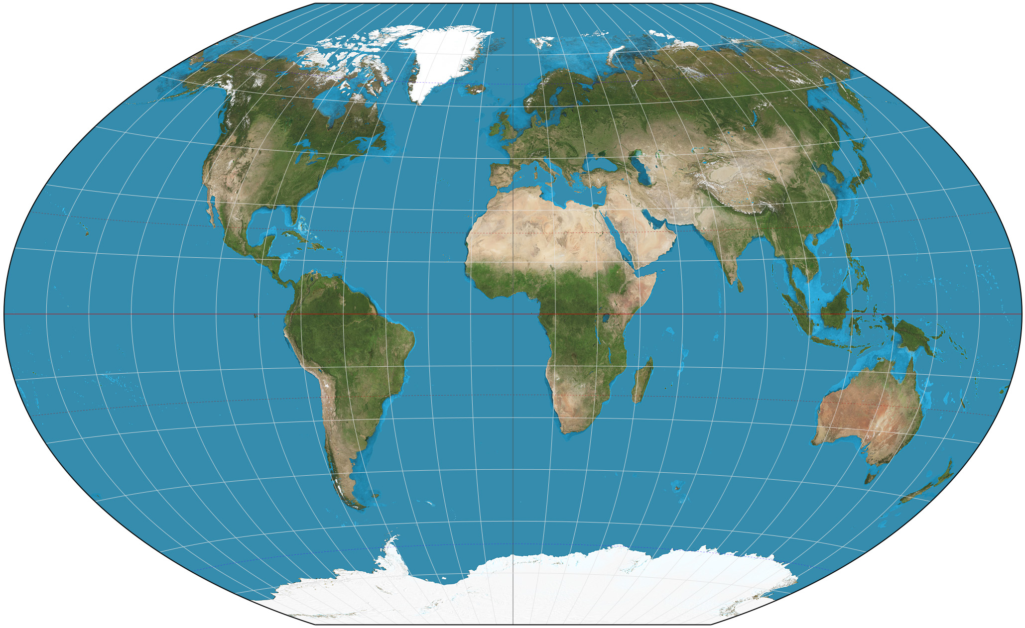
The history and evolution of the world map span thousands of years, from early cartography in ancient civilizations to the digital mapping technology of the modern era. Ptolemy’s geocentric model and the Age of Exploration greatly influenced early map-making, while the Mercator projection and its controversies revolutionized how we view the world. Today, digital mapping technology advances, offering new ways to visualize and understand our planet.
- Early Cartography: From Ptolemy to the Age of Exploration
From Ptolemy to the Age of Exploration, early cartography laid the foundation for modern map-making. Ptolemy’s geocentric model influenced map-makers for centuries, while the Age of Exploration led to the discovery of new lands and more accurate maps. Explorers such as Christopher Columbus and Ferdinand Magellan made significant contributions to cartography, improving navigation and charting previously unknown territories. These early maps are now invaluable resources for historians and geographers seeking to understand the world as it was centuries ago.
- The Mercator Projection and its Controversies
The Mercator projection is a cylindrical map projection that revolutionized the world of cartography. Created by Flemish cartographer Gerardus Mercator in the 16th century, it allowed navigators to plot straight courses across the seas. However, the projection is criticized for its distortion of landmass sizes, making northern hemisphere countries appear larger than they are. The Mercator projection has also been criticized for its Eurocentric bias. Despite its controversies, the Mercator projection remains widely used today.
- The Modern Era of Cartography
Digital mapping has transformed the field of cartography in the modern era. Computer software and satellite technology have created highly detailed and accurate maps, making it easier to navigate and understand the world. The rise of digital mapping has also made it possible to explore remote and inaccessible areas of the globe.
Understanding the Features of the World Map
The world map visually represents the planet, displaying its continents, oceans, countries, and physical features such as mountains, rivers, and deserts. It also shows political boundaries, such as countries and their capitals. Latitude and longitude are used to navigate the globe, with lines of latitude running east-west and longitude running north-south. Understanding these features is crucial for navigation, travel, and international relations. Additionally, mapping the Earth’s resources and natural hazards is vital for environmental and geological studies. A world map is essential for understanding the planet’s complex systems.
- Continents and Oceans: The Basic Building Blocks
Continents and oceans are the basic building blocks of the world map. The world is divided into seven continents, which include Africa, Antarctica, Asia, Australia, Europe, North America, and South America. These landmasses are surrounded by five oceans: the Atlantic, Pacific, Indian, Southern, and Arctic. Understanding the location and size of these continents and oceans is crucial for navigation and international relations. The distribution of natural resources and biodiversity also varies significantly among these continents and oceans, making them an essential focus of environmental and geopolitical studies.
- Latitude and Longitude: Navigating the Globe
Latitude and longitude are essential for navigating the globe. Latitude measures the distance from the equator towards the north or south, whereas longitude measures the distance from the prime meridian towards the east or west. These imaginary lines intersect at specific points, allowing for the precise location of any place on Earth to be determined. Understanding latitude and longitude is crucial for navigation and communication and is used in various fields, including meteorology, geology, and astronomy. With the help of latitude and longitude, we can quickly locate any place on the Earth’s surface and navigate our way around the world.
- Physical and Political Features: Mountains, Rivers, Countries, and Capitals
The world map displays physical features such as mountains, rivers, deserts, and oceans and political features like countries, states, and their capitals. Mountains and rivers are important natural features that have shaped the Earth’s landscape and are essential for agriculture and transportation. Countries and their money are shown on the map to depict political boundaries and navigation aid. Understanding these features is critical for geography and history and helps us understand the diversity of cultures, languages, and traditions worldwide.
Applications of the World Map
The world map has many applications, from navigation and travel to environmental studies and international relations. It is used in geography and history to understand the distribution of natural resources and the patterns of human settlement. The world map also plays a crucial role in climate studies, with information on ocean currents, wind patterns, and temperature variations. In addition, the world map is used to track natural disasters such as earthquakes, hurricanes, and floods. Political scientists use the world map to analyze international relations, trade, and conflict. The world map also plays a vital role in tourism, allowing travelers to plan their journeys and explore the world. Overall, the world map is an essential tool for understanding the planet and its complex systems and the diversity of cultures and environments that make up our world.
- Travel and Tourism: Planning Your Next Adventure
Travel and tourism are popular activities for those exploring new destinations and cultures. With the help of the world map, travelers can plan their journeys, choose their goals, and navigate their way around the world. Online resources and travel agencies offer a wealth of information on flights, accommodations, and activities, making it easier than ever to plan your next adventure. Travel and tourism provide an opportunity to relax and unwind, learn about different cultures, meet new people, and create lasting memories. With careful planning and a sense of adventure, travel, and tourism can enrich experiences.
- Geopolitics and International Relations: Understanding the World Order
Geopolitics and international relations are critical components in understanding the world order. The world map serves as a tool for political analysis, demonstrating the distribution of natural resources, population centers, and economic zones. Political scientists use the world map to analyze international relations, trade, and conflict. Political boundaries and their change over time are reflected on the world map. Understanding the world order and its underlying dynamics is crucial in maintaining peace and stability and promoting economic development and human rights. By studying the world map and geopolitical trends, governments and individuals can make informed decisions that impact the world’s future.
- Environmental and Geological Studies: Mapping Natural Resources and Hazards
A world map is a valuable tool for environmental and geological studies, helping to map natural resources and hazards. Scientists use the map to identify areas of biodiversity, natural disasters, and geological features like faults and volcanoes. Understanding the distribution and characteristics of natural resources and hazards is essential for sustainable development and disaster management. The world map plays a vital role in these efforts, providing valuable data for research and analysis.
In conclusion,
A world map is crucial for understanding our planet, its features, and its people. The world map has evolved from early cartography to digital mapping, reflecting changing political and social dynamics. It is used in various fields, from geography and history to environmental studies and international relations. The world map is a foundation for navigating the globe, planning travel and tourism, and analyzing geopolitical trends. It also helps us to understand the diversity of cultures and environments that make up our world and to work toward sustainable development and disaster management. The world map continues to be an essential tool for exploring and understanding our planet and shaping our future.
Also, Read: NIO Stock: Analyzing the Electric Vehicle Company’s Performance


Discussion about this post